Natural Heritage on Fire: Lessons for Built Heritage Professionals
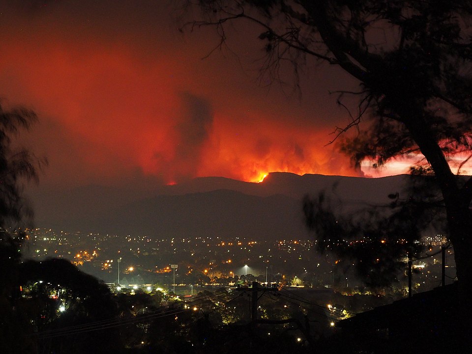
Camberra 2020 Fire (image: vNick-D, CC BY-SA 4.0, via Wikimedia Commons)
Historic buildings nestled in forests, parks, or scrubland increasingly face wildfire threats amplified by climate shifts, as evidenced by 2025–2026 natural heritage losses.
Site managers of hill towns, rural estates, or park lodges, as well as any historic building that can be exposed to this insidious threat, can adapt ecosystem fire management strategies to safeguard masonry, timber frames, and thatched roofs while respecting authenticity constraints.
Key Recent Cases
Tongariro National Park (New Zealand, UNESCO site) burned 2,500+ hectares in November 2025 from drought, 50 km/h winds, and possible lightning—embers menaced trailside huts despite aerial ops. Scotland’s Glen Rosa (Arran) lost 27,000 trees over 1,000 hectares in April 2025, sparked by sunlight-focused glass litter, erasing National Trust rewilding efforts. Argentina’s Los Alerces National Park saw 12,000+ hectares of ancient forests torched in early 2026 amid arson suspicions, evacuating 3,000 and exposing fuel load dangers. These underscore ember intrusion and heat as killers of even stone heritage.
Why Wildfires Threaten Historic Buildings
The primary concern is the potential damage to built heritage from wildfires. The risk of damage, from superficial to complete loss, is rarely directly related to the flames due to impingement.
A more subtle risk is that flying embers produced by tree combustion can travel hundreds of kilometres and ignite specific superficial parts of a building. This process poses a significant problem for owners and fire services as it can rapidly spread the area of direct risk during a wildfire.
Consequently, owners and managers cannot rely on fire services to limit damages as they may be fully involved in other areas and unable to intervene in a timely manner..
Key recent cases illustrate the patterns. Tongariro National Park (New Zealand, UNESCO dual World Heritage site) endured a November 2025 wildfire scorching 2,500+ hectares amid extreme drought and 50 km/h winds; sparked by lightning or human activity, it prompted multi-day aerial drops and evacuations, with embers threatening trailside huts.
In April 2025, Scotland’s Glen Rosa valley (Isle of Arran) saw drought-ignited flames destroy 27,000 young trees and moorland shrubs over 1,000 hectares, likely from focused sunlight via discarded glass—undoing a decade of National Trust rewilding.
Early 2026 brought devastation to Argentina’s Los Alerces National Park (UNESCO), where 12,000+ hectares of ancient alerce forests burned under similar dry, windy conditions with suspected arson, forcing 3,000 evacuations and highlighting fuel load risks.
For built heritage, these reveal ember intrusion, radiant heat (up to 1,000°C at 10m), and vegetation bridges as primary vectors—even stone structures suffer soot, cracking, or roof loss.
Actionable Measures for Site Managers
These steps follow CAL FIRE, NFPA 1144 (wildland-urban interface), and European heritage adaptations, prioritized by cost/effort.
- Defensible space zoning (highest ROI):
Implement three concentric zones. Australian/New Zealand standards (AS 3959/NZS 4517) identify three areas:- Zone 1 (0–1.5m from building): Zero combustibles—no mulch, plants, or woodpiles. Pave/gravel surfaces; elevate wood decks on non-combustible pillars. Inspect quarterly.
- Zone 2 (1.5–10m): Low-fuel plants only (e.g., lavender, succulents); prune trees to 4m height/crown separation 2x trunk diameter. Remove lower branches (ladder fuels) to 2m. Mow grass <10cm weekly in summer.
- Zone 3 (10–30m): Thin canopy to 40% cover; space trees 10–15m apart. Create 4m-wide firebreaks with mowed paths or rocky clearings. Annual professional thinning for >30m slopes. Cost: €500–2,000/year for 1ha.
- Ember and radiant heat defences (structure hardening):
Embers are one of the worts problem. Install 2mm stainless steel mesh (non-corrodible) on all vents, eaves, subfloor, attic inlets, and weep holes—proven to block 99% of embers <5mm. Seal gaps >5mm with fire-rated intumescent sealant or mineral wool (non-asbestos). Upgrade gutters to metal with leaf guards; fit Class A (steel) roofs if replacing thatch/shingles. Multi-pane glass or wired glass for windows facing vegetation. Retrofit cost: €10,000–50,000 for a 500m² building. - Vegetation and fuel load management:
Target invasive species such as gorse broom or pampas grass: Cut or mulch annually before summer; use goats or sheep for natural grazing on slopes (e.g. Arran model). A more professional intervention is based on the use of controlled burns (also known as prescribed fire). Controlled burns in buffer zones every 3–5 years to reduce understory. In this case local authority approvals may be required and the practice should be carried out by professionals. In most complex cases, monitoring via drone or ground surveys for deadwood may be necessary. Furthermore herbicides near stonework should be avoided due to their chemical properties which can chemically react with and degrade porous masonry materials. - Water supply and suppression readiness:
Secure a minimum static supply of 10,000 litres from a pond or tank within 100 metres, with couplings compliant with fire service trucks. Install three 30m hose reels (15 bar) at the corners, tested biannually. For remote sites, solar pumps and bladder tanks should be installed. Pre-position foam extinguishers for spot fires. It is important to consider that pump and pipe maintenance should be a priority in the event that such measures are adopted. - Early warning, monitoring, and liaison:
Integrate low-cost IoT sensors (smoke/heat/wind) linked to site alarms and fire service apps. Use free tools like EFFIS (European Forest Fire Information System) for forecasts. - Low/no-budget starters (immediate):
Daily summer patrols (embers/smoke); ban BBQs/open flames with signage; community education on “no glass litter.” Annual insurance-driven risk walk with photos/log. Volunteer crews for vegetation cuts.
Governance
Historic buildings in forested or scrubland settings face intensifying wildfire risks, exacerbated by climate-amplified droughts and winds. This is evident from recent natural heritage losses such as Tongariro, Glen Rosa and Los Alerces.
Directors could consider the establishment of a ‘wildfire coordinator’ reporting quarterly. This measure preserved 90% of structures in recent California heritage events.
Actionable Measures for Site Managers
Prioritise following CAL FIRE, NFPA 1144 and EU heritage guidelines based on ROI. A Fireriskheritage summary is provided below.
Defensible Space Zoning (Highest ROI)
Create three zones i.e. according the Australian “Construction of buildings in bushfire-prone areas”AS 3959/NZS 4517 standards:
- Zone 1 (0–1.5m): No combustibles—remove mulch/plants/woodpiles. Use gravel/pavers; raise decks on concrete/steel pillars (load-rated to 500kg/m²). Inspect quarterly with photos; sweep leaves daily in fire season.
- Zone 2 (1.5–10m): Low-fuel plants (lavender, rosemary, succulents <0.5m tall); prune trees to 4m height, crowns 2x trunk diameter apart. Limb up “ladder fuels” to 2m; mow grass <10cm weekly (use metal reel mowers for sparks). Example: For a 200m² villa, this takes 4–6 hours biweekly.
- Zone 3 (10–30m): Thin canopy to 40% coverage; tree spacing 10–15m (measure trunk-to-trunk). Cut 4m-wide firebreaks (mowed paths, gravel, or rocky outcrops). On >30° slopes, hire arborists for annual thinning (€500–2,000/ha; source via local forestry co-ops). Italian sites: Coordinate with Carabinieri Forestali for permits.
Ember and Radiant Heat Defenses (Structure Hardening)
Embers cause 80–90% of structure losses.
- Fit 2mm stainless steel mesh (316-grade, 0.5mm wire) to vents/eaves/subfloors/attics/weepholes—blocks 99% of <5mm embers (test per ASTM E2886). Source: Hardware chains (€20/m²).
- Seal >5mm gaps with intumescent sealant (e.g., Promat Promaseal) or rockwool (density >120kg/m³, non-asbestos). Clean gutters; install metal leaf guards (slope 1:100).
- Roofs: Class A steel/tiles if re-roofing (underlay with sarking). Windows: 6mm wired glass or double-glazing (tempered, low-E). Retrofit: €10–50k for 500m² (DIY mesh: €2–5k; pro install: add 50%). Practical tip: Start with roof valleys/eaves (highest ember catch).
Vegetation and Fuel Load Management
- Target invasives (gorse, broom, pampas): Cut/mulch pre-summer (use chippers for <10cm branches); graze with goats/sheep (rent via apps like GoatsOnCall, €100/day/ha, Arran-style).[2]
- Prescribed burns: A more professional intervention is based on the use of controlled burns (also known as prescribed fire). Controlled burns in buffer zones every 3–5 years to reduce understory. Every 3–5 years in buffers (>20m from buildings), by certified crews —reduces understory 70%. Get local services approval; burn <5ha patches.
- Monitor: Annual drone surveys (€300/session) or ground walks for deadwood (>10% fuel load triggers action). Avoid herbicides near stonework: Glyphosate/acids etch limestone/marble (forms soluble gypsum, pitting details 0.5–2mm/year); salts weaken lime mortars (20–50% strength loss). Use steam (150°C, €500/portable unit) or vinegar (10% solution, rinse immediately).[10][11]
Water Supply and Suppression Readiness
- Static supply: 10,000L tank/pond <100m away, with 64mm Storz couplings (Euro standard). Mark with reflective signs or the couplings adopted by local fire service.
- Hoses: 3x 30m reels (19mm, 15 bar, fog nozzles) at corners; test flow biannually (min 200L/min). Remote: Solar pumps (200W panel, 2m³/hr) + 1,000L bladders.
- Tools: 10x 9L foam extinguishers (Class A/B, check expiry). Maintenance: Flush pipes yearly; winterize pumps..
Early Warning and Monitoring
Keep informed through information services like EFFIS in the European Union or US:
- InciWeb (inciweb.nwcg.gov): Official interagency platform by National Wildfire Coordinating Group (NWCG)—provides real-time wildfire maps, incident details, evacuation alerts, and forecasts across US states. Free daily updates, app integration; used by Forest Service/FEMA for public/land manager briefings. Covers national parks/heritage sites directly.
- USGS Fire Danger Forecast (usgs.gov/fire-danger-forecast): Daily 1–7 day predictions of large-fire risk using satellite/NOAA weather data. Color-coded maps (low/moderate/high/extreme) for conterminous US; ideal for pre-positioning resources at historic sites. Complements NWS Red Flag Warnings.
Conclusion
Wildfires no longer spare remote heritage; Tongariro’s embers and Patagonia’s fuel loads signal a new era where every forested site must harden proactively. Unlike urban blazes, rural fires demand owner-led defenses—fire services arrive post-spot ignition, leaving managers as first responders. This post equips you with specs, costs, and standards to act within budgets, from €0 patrols to €50k retrofits, ensuring compliance i.e. with NFPA 909/914.
European hill towns face identical risks: invasive bracken on slopes mirrors Arran’s gorse, while summer winds carry embers like Tongariro’s. Local tools—Fire service partnerships, EFFIS alerts, CFVA burns—make implementation feasible. Start small: Zone 1 today, full hardening in 24 months.
FireRiskHeritage.net tracks these threats so you don’t reinvent post-loss. Share your site’s “before” photos in comments; subscribe for 2026 updates. Turn vulnerability into resilience—your buildings deserve it.