From Vineyards to Vaults: How Managed Landscapes Can Help Protect Cultural Heritage in a Warming Mediterranean
Climate change is reshaping fire weather across the Mediterranean and temperate Europe. Recent projections suggest that even at modest levels of global warming, dangerous fire-weather days are becoming more frequent and intense, with longer peak seasons and increased risk even during traditionally “off-season” periods.
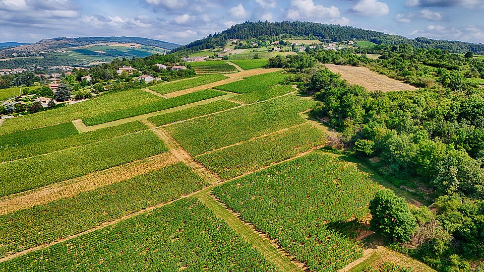
Vineyard landscape in Burgundy, France, shown as an example of managed agricultural land that may contribute to wildfire risk reduction. Image: FrogsLegs71, CC BY-SA 3.0 <https://commons.wikimedia.org/wiki/File:Vineyards_in_Burgundy_France.jpg>, via Wikimedia Commons
According to available reporting, more than one million hectares burned across the EU in 2025. That figure underlines how climate-driven fire risk now directly threatens rural communities and the cultural landscapes embedded within them.
At the same time, EU-level narratives are beginning to frame vineyards not only as cultural landmarks but also as potential elements of local resilience strategies, provided they are properly integrated into fire management plans.
The 2026 European Heritage Days are reported to focus on “Heritage at Risk: Revive, Resist, Reimagine” which signals strong institutional interest in proactive, landscape-scale approaches to heritage protection.
In other words: protecting cultural heritage increasingly means looking beyond the monument and considering the entire territory in which it is embedded.
Vineyards as multifunctional landscapes
Vineyards are gaining attention not only for their cultural, economic and landscape value, but also for their potential role in local resilience.
Mechanistically, well-managed vineyards can influence fire behavior in several ways:
1. Reduced continuous fuel loads
Regular pruning, weed control and soil management can break up the continuity of surface fuels that carry low-intensity fires.
2. Lower vegetation continuity in certain conditions
Compared with unmanaged scrub or dense forest, a well-maintained vineyard may present a more open structure and reduced fuel continuity. However, this is not automatic: it depends on management practices, vine training systems, understory conditions and local climate.
3. Access tracks and service roads
Vineyard paths, rural roads and service tracks can create linear openings in the landscape. When maintained, they may function as informal fire breaks and useful access routes for firefighters.
But let’s be clear: a vineyard is not automatically a fire break. Poorly managed vineyards, with dense understory growth, abandoned plots or accumulated dry biomass, can increase local fire risk.
The key is intentional design and coordination between landowners, local authorities and civil protection services.
From concept to territorial safety plans
How can this idea move from concept to practice? A pragmatic pathway could look like this.
1. Map heritage clusters and exposure
Start by mapping:
- Heritage clusters: historic villages, monastic complexes, archaeological parks and other high-value assets.
- Fire exposure: available hazard maps and, where possible, interactive tools that visualize settlement exposure to wildfires in transboundary regions.
- Prevailing wind directions and topographic channels that may guide fire spread toward heritage assets.
This spatial analysis helps identify where landscape interventions could have the greatest impact.
2. Identify existing and potential landscape fire breaks
Overlay the location and structure of:
- Existing vineyards, olive groves, orchards and other managed agro-landscapes around heritage clusters.
- Abandoned or semi-abandoned agricultural areas that could be restored or repurposed.
- Existing tracks, rural roads and irrigation infrastructure that could be enhanced as part of a fire-break network.
The goal is to identify lower-risk corridors where agricultural land use already reduces fuel continuity — or could do so with relatively low-cost interventions such as targeted pruning, controlled grazing and understory management.
Rather than speaking automatically about “green firewalls,” it is more accurate to think of these areas as fuel-reduction belts or landscape fire breaks.
3. Integrate them into civil protection and site-specific plans
Once identified, these landscape elements should be explicitly included in:
- Municipal civil protection plans, as part of territorial risk reduction measures, not only as economic or touristic zones.
- Site-specific emergency plans for heritage complexes, referencing surrounding land use in risk assessments and pre-incident planning.
- Training and drills, ensuring that local communities, site managers and fire brigades understand how these landscape features may affect fire behavior and response options.
Recent pilot training programs on disaster risk management for cultural heritage underscore the value of structured, scenario-based capacity-building in this area.
Linking landscape fire breaks to evacuation modeling
For researchers and practitioners working on evacuation and pedestrian behavior, landscape fire breaks open up new modeling questions.
Traditional evacuation scenarios often focus on built environments: corridors, stairwells and exits. In rural and peri-urban heritage contexts, however, the “egress system” extends into the landscape itself.
Scenario design
Consider two broad scenarios for a heritage village or site cluster:
Baseline scenario:
A wildfire approaches under given weather and fuel conditions, with no intentional landscape fire breaks. Evacuation routes follow existing roads and paths, which may be quickly compromised by smoke, heat or direct flame contact.
Intervention scenario:
The same fire occurs, but managed vineyard or orchard belts and maintained tracks form a network of lower-risk corridors around and away from the heritage cluster.
Using social-force or agent-based evacuation models, you can explore:
- Changes in available safe egress time (ASET) for residents and visitors.
- Comparison with required safe egress time (RSET).
- Shifts in preferred routes as people follow visible, maintained tracks through agro-landscapes rather than dense vegetation or narrow, smoke-filled streets.
- Interactions between civilian evacuation flows and firefighter access routes, especially where vineyard tracks may serve both purposes.
Data needs and AI analytics
To make these models realistic, several data layers are needed:
- High-resolution land-use and vegetation structure data, including vineyard layout, pruning regimes and understory conditions.
- Local weather and fire-weather indices, potentially from IoT sensor networks or downscaled climate products.
- Behavioral data on how residents and tourists actually move in rural heritage contexts during emergencies.
AI analytics and sensor fusion can help by:
- Integrating remote sensing, weather data and ground reports to update fire spread and risk maps in near real time.
- Feeding dynamic inputs into evacuation simulations, allowing “what-if” testing of different landscape management strategies.
- Supporting decision tools for site managers and civil protection authorities during both planning and operations.
However, these tools should be used with caution. They need validation, uncertainty management, clear data governance and attention to privacy and cybersecurity issues.
From vineyards to vaults: protecting movable heritage too
The title is not just poetic. Protecting a historic village also means protecting what it contains: archives, collections, artworks and high-value movable heritage.
Landscape fire breaks do not replace i.e. a museum crisis protocols. They complement them. A robust heritage safety strategy should still include:
- Prioritized evacuation of people.
- Protection of high-value artifacts and irreplaceable collections.
- Coordination with emergency services.
- Clear procedures for archives, storage rooms and vaults during a crisis.
In short: the landscape helps reduce exposure, but internal protocols determine how quickly and safely people and objects can be protected once an emergency begins.
A practical checklist for heritage site managers
For heritage site managers, local authorities and consultants, the following checklist can help translate the concept into action.
1. Include surrounding land use in fire risk assessments
Treat vineyards, orchards, forests and scrubland around heritage assets as integral parts of the site’s risk profile — not just background scenery.
2. Collaborate with landowners and farmers
Work with local agricultural stakeholders to align pruning schedules, grazing practices, understory management and road maintenance with fire-break objectives.
3. Reflect landscape fire breaks in emergency documentation
Make sure that:
- Evacuation plans and signage explicitly reference safe routes through agro-landscapes.
- Pre-incident plans shared with fire brigades include information on vineyard tracks, access points and water sources.
- Site-specific plans account for seasonal changes in vegetation and accessibility.
4. Train and drill on landscape-based scenarios
Training should not be only building-centric. Include scenarios where fire approaches from the surrounding landscape and evacuation routes pass through agricultural areas.
5. Coordinate with broader crisis protocols
Align landscape measures with existing museum and heritage crisis practices, such as prioritized evacuation of people, protection of high-value artifacts and coordination with emergency services.
6. Assign responsibilities, timelines and indicators
To make the checklist operational, define:
- Who is responsible for each action.
- When maintenance and training should take place.
- What resources are needed.
- Which indicators will be used to monitor effectiveness over time.
Reimagining heritage landscapes as living safety systems
Protecting cultural heritage in the 21st century means rethinking what “protection” looks like.
It is no longer sufficient to focus only on walls, roofs and internal systems. Heritage sites exist within living landscapes that are themselves changing under climate pressure.
Vineyards and other traditional agro-landscapes can be reinterpreted as living infrastructure for safety: cultural, economic and ecological assets that also contribute to territorial resilience. When intentionally managed and integrated into civil protection and heritage risk plans, they can help slow fire spread, create safer evacuation corridors and give firefighters better access to at-risk assets.
This perspective resonates with emerging narratives on heritage and climate in the Mediterranean, which call for approaches that combine technical risk reduction with the stewardship of living cultural landscapes.
It also aligns with the spirit of European Heritage Days 2026, which invite us to revive, resist and reimagine how we protect what matters.
This article was researched, written and edited by Stefano Marsella.