BIM/GIS Fire-Risk Models for Heritage: Why Interoperability Is Still the Core Problem
Recent research on BIM and GIS for heritage fire-risk assessment shows strong potential, but interoperability remains the main obstacle. This article explains why linking HBIM and GIS is still difficult, and why that gap matters for real-world practice.
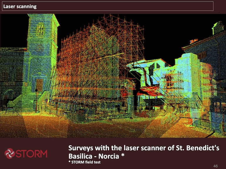
Surveys with the laser scanner of St. Benedict's Basilica - Norcia (STORM field test) - Image from: Marsella, S., Garzia, F., et al. “3D imaging to improve damage restorations: the case of the Papal Basilica and Sacred Convent of Saint Francis in Assisi, Italy.” Italian Fire Brigades / Progetti Europei portal, PDF
Recent research on BIM and GIS for heritage fire-risk assessment has produced promising results, but one issue continues to dominate the discussion: interoperability. In principle, HBIM and GIS should complement each other very well.
HBIM can describe the building itself in detail, while GIS can place that building within its wider spatial context, including access routes, exposure, topography, surrounding hazards, and emergency logistics. In practice, however, the two systems often remain difficult to connect in a smooth and reliable way.
This matters because heritage fire risk is not confined to the building envelope. It is shaped by the relationship between internal layouts, construction materials, hidden cavities, site access, water supply, surrounding vegetation, adjacent structures, and emergency response conditions.
A useful digital workflow should be able to bring all of these factors together. Instead, many current approaches still rely on repeated manual adjustments, file conversion, and expert interpretation to make the data usable across platforms.
That is why interoperability should be seen not as a technical detail, but as the central bottleneck in the development of BIM/GIS fire-risk models for heritage.
Research has demonstrated the potential of these systems and highlighted some existing gaps. However, this post will concentrate on their ability to effectively support daily decision-making in conservation fire safety and emergency planning. Until then, many advanced models will remain impressive prototypes rather than practical tools.
Why interoperability matters
Interoperability is the ability of different digital systems to exchange, interpret, and use information without excessive manual intervention. In the heritage fire-risk field, this means more than simply exporting a file from one platform and importing it into another. It means preserving the meaning, structure, and usefulness of the data as it moves between HBIM, GIS, inspection records, risk registers, emergency plans, and visualisation tools.
When that chain breaks, the value of the whole model is reduced.
The problem is especially serious in heritage settings because the data are rarely clean or complete. Historic buildings often have multiple phases of alteration, hidden structural features, incomplete surveys, and documentation scattered across different formats.
Some information may exist in CAD drawings, some in spreadsheets, some in paper archives, and some only in the knowledge of the site team. When these materials are brought into a digital workflow, the lack of common standards quickly becomes visible. The result is often duplication, inconsistency, and a heavy workload just to keep the model functional.
This is one reason why many research projects remain limited to case studies. They can demonstrate the concept, but they do not always solve the broader integration problem. A model that works for one heritage building may not transfer easily to another, especially if the software stack, data quality, or site documentation differs.
For practitioners, this creates an important question: is the digital model truly supporting the work, or is the team spending too much time adapting the model to the reality of the site?
The practical gap in current models
The practical gap becomes clearer when these systems are used for actual fire-risk tasks. A heritage site manager may need to update an evacuation route, review a high-risk zone, compare access options for fire appliances, or check whether a new conservation intervention has changed the fire profile of the building.
If HBIM and GIS are not fully interoperable, each of these tasks may require separate work in separate software environments. That slows down the process and increases the risk of errors.
This is also where the difference between research output and operational value becomes most visible. A study may produce a sophisticated visual model, but if the workflow is too complex for a real site team to maintain, it will have limited long-term value.
Heritage fire safety needs tools that are not only accurate, but also durable, updateable, and understandable by multiple users. That means interoperability must be designed into the system from the start, rather than treated as an afterthought.
The wider lesson is simple. The field does not just need more digital innovation; it needs better integration. Until HBIM and GIS can work together consistently across different sites, scales, and data types, the promise of digital fire-risk assessment for heritage will remain only partially fulfilled.
This is the gap that future research — and future applied services — still need to close.
Read more about HBIM in Cultural Heritage Buildings Management: Advantages, and Limitations: