Engineering the “AEGIS” fire‑protection network for Greek archaeological sites
Greece’s 2026 fire‑protection programme for archaeological sites is organised around a national early‑detection and response network, implemented under the Civil Protection programme “AEGIS” (ΑΙΓΙΣ) and financed through the EU Recovery and Resilience Fund. The system integrates thermal and optical sensors, AI‑based analytics, meteorological data, and local suppression assets into a coordinated architecture designed to reduce time‑to‑detection and support faster, better‑informed firefighting operations at 22 major heritage locations.
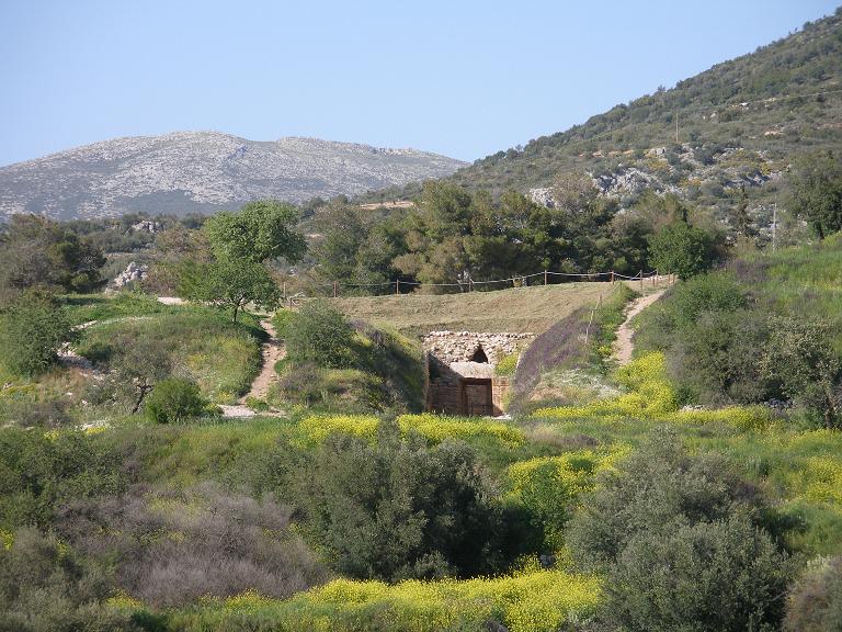
The Tomb of Aegisthus in Mycenae. The dense vegetation surrounding the site underscores the high risk of fire during the dry season.(Credits: Georgeuoa CC BY-SA 3.0 <http://creativecommons.org/licenses/by-sa/3.0/>).
Greece’s 2026 fire‑protection programme for archaeological sites is organised around a national early‑detection and response network, implemented under the Civil Protection programme “AEGIS” (ΑΙΓΙΣ) and financed through the EU Recovery and Resilience Fund.
The system integrates thermal and optical sensors, AI‑based analytics, meteorological data, and local suppression assets into a coordinated architecture designed to reduce time‑to‑detection and support faster, better‑informed firefighting operations at 22 major heritage locations.
Institutional framework and implementing bodies
The overall initiative is led by the Ministry of Culture, in coordination with the Hellenic Fire Service and the national civil‑protection apparatus. Implementation falls under the National Civil Protection Programme “AEGIS”, with procurement and contract management handled by the Hellenic Asset Development Fund (Υπερταμείο) as part of broader upgrades to civil‑protection infrastructure.
While specific engineering firms and system integrators are not always named in public communications, the project structure indicates a multi‑actor delivery model:
- Client and policy owner: Ministry of Culture, with operational linkage to the Fire Service and Civil Protection.
- Procurement and oversight: Hellenic Asset Development Fund (Υπερταμείο), running the tender process for supply and installation.
- Funding instrument: Recovery and Resilience Fund (RRF), framing the works as climate‑adaptation and critical‑infrastructure protection.
This arrangement separates policy definition (heritage protection), operational requirements (fire service needs), and technical delivery (procurement and installation), allowing specialised contractors to design and deploy the sensor networks and control systems under a unified national specification.
System architecture: sensors, analytics, and control centres
At each site, the fire‑protection system comprises several interoperating layers:
Sensor layer
- Thermal and optical cameras: Fixed and PTZ (pan‑tilt‑zoom) units provide continuous surveillance, combining visible‑light imagery with thermal signatures to detect abnormal temperature patterns, smoke, or incipient flames.
- 360° coverage and remote operation: Some cameras offer 360° rotational capability and remote control, enabling operators to focus on specific sectors or suspected hotspots.
- Meteorological stations: On‑site weather sensors record wind speed and direction, temperature, humidity, and other parameters relevant to fire behaviour.
Analytics and decision‑support layer
- AI‑based detection algorithms: Software processes thermal and optical feeds in real time, using pattern recognition to distinguish genuine fire signatures from benign heat sources or transient phenomena.
- Automated alerts: When thresholds are exceeded, the system generates auto‑alerts with timestamps, geolocated hotspots, and live video/thermal feeds.
- Geospatial interface: A map‑based operator console displays detected incidents, alarm times, equipment status, and camera views in an integrated dashboard.
Operational layer
- Control centres: Regional and coordinating control centres receive alerts and situational data, supporting rapid assessment and resource allocation.
- Fire Service integration: Real‑time information is transmitted directly to the Hellenic Fire Service, enabling faster dispatch and more precise initial attack planning.
- Local suppression assets: At selected sites, portable firefighting cannons (monitors) and other equipment are pre‑positioned to allow immediate intervention by site personnel or first responders.
Performance evidence: the Mycenae–Fichtia test case
The system’s effectiveness was demonstrated during a wildfire on 31 July 2026 near Fichtia, Argolis, within the surveillance envelope of the Mycenae installation. The detection network identified the incipient fire, triggered an automated alert, and transmitted live imagery and incident data to the coordinating control centre.
This sequence illustrates the intended operational loop: early detection → automated notification → real‑time situational awareness → accelerated operational response.
Implications for fire‑risk engineering at heritage sites
The Greek AEGIS programme illustrates how fire‑risk engineering for cultural heritage can move beyond ad‑hoc measures toward a systematic, networked approach:
- Standardised national specification: A common technical baseline across 22 sites allows shared training, maintenance, and operational procedures, while accommodating site‑specific layouts and risk profiles.
- Data‑driven operations: Continuous sensor data and incident logs can support post‑event analysis, refinement of detection thresholds, and evidence‑based updates to site fire‑risk plans.
- Scalability: The architecture can be extended to additional sites or integrated with broader landscape‑level fire‑detection networks, creating a hierarchical system from local to regional scales.
For engineers and risk managers working at the interface of fire safety and heritage conservation, the AEGIS network offers a reference model for designing reversible, technology‑enabled protection systems that align operational effectiveness with conservation constraints.